Since my chance to see the Þingvellir and the Almannagjá rift in anything resembling sunshine yesterday vanished in a drizzling rain, they are on our schedule again for today. While Mark was diving at Silfra, I waited too long while the sun was coming out and by the time I started to wander up to the viewpoint over the primary rift…the clouds rolled in and it started to rain again. I feel like an idiot — I should have learned by now that if the sun peeks out, run! Get outside and get what pictures you can, don’t dilly-dally downloading pictures because the sun is going to disappear at any moment!
Either way, we set out this morning from Selfoss after eating Skyr and cake for breakfast at the local bakery, with the intention of heading inland on Route 30 to view one of the “beautiful scenic routes” on our map. A few waterfalls, a few lovely views, some ancient viking-era settlements. The weather didn’t really cooperate today. We were promised sun, but I’ve come to realize that the weather is simply so changeable and varied over even short distances that it’s worthless to plan based on it. Today is gray, but not particularly blustery, which is a nice change. A few peeks of blue sky, but mostly the low-hanging clouds are dominating everything.
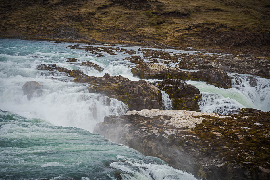
Right off the road only a few minutes from Selfoss is the wide, thundering span of Urriðafoss, the highest volume waterfall in Iceland, spanning the longest river in Iceland. Lots of -ests in one place. This isn’t a very tall waterfall, but the river is fast and moves enough water that there are plans to add a huge hydroelectric plant just upstream, which may destroy the falls as they are now. This is, obviously, a touchy subject with locals and they are vocally opposed to it. It is possible to get very close to the waterfall, and it is a short walk from the gravelled parking area. I have to keep reminding Mark not to walk out on the rocks, he has a tendency to be a bit of a daredevil. Like most places in Iceland, danger signs and ropes or railings are a rarity — Icelanders assume you are a rational, reasonable person and won’t do anything truly stupid. Tourists have a tendency towards lack of self-preservation, I think. We get so awed by the scenery that we don’t pay attention. (As I write this, a German tourist fell to his death at Macchu Picchu, stepping over a rope to get a selfie, which may be less an underdeveloped sense of self-preservation than being truly oblivious once the cell phone comes out).
Our map has a lookout marked over the Þjorsá river and Hekla volcano marked on the way to the Þorsadalur valley, which is as far inland as we can make it this time of year. The roads are good, mostly paved, and the views are spectacular on the way into the Fjallabak Nature Reserve and Landmannalaugar — which are really only accessible by 4×4 and hiking. There are well-known multi-day hiking trails through the Landmannalaugur region, with camping huts and spectacular scenery. While I’m sure we could have hiked — we certainly saw people geared up to do it — it’s not on our agenda this trip. Some of the most gorgeous photos I have ever seen of Iceland are from this region. So, while we aren’t venturing into the actual park, we can touch on the edges.
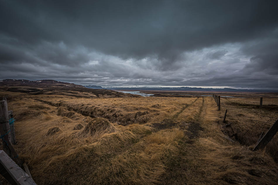
Using our not-quite-road-map, we misjudged the road to the lookout, Gaukshöfði, and ended up driving through a couple of small farms. I can’t blame the map, really — we know it’s not really a road map (even if the main roads are all marked), but there really aren’t that many paved roads around that you need Geo Survey-level maps and so we thought we’d be ok. We took the first left that seemed right and it looped around a few farms and revealed some interesting photo ops but eventually dumped us unceremoniously on the main road again. Well, like most things that happen by accident, it was worth the detour. Pretty atmospheric, eh?
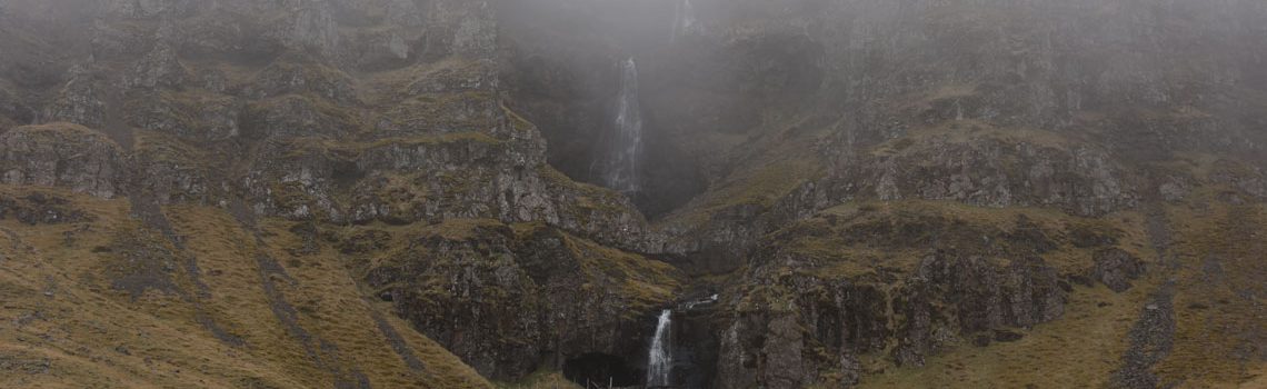
The dominating feature in this area are the vast lava fields and slopes of a Hekla. I expected Hekla, the most active of Iceland’s volcanos, to be much larger. It has erupted more than 20 times since 874 and rumbles ominously even now. Wikipedia notes that about 10% of the tephra (volcanic stone and ash) in Iceland in the last millennia came from Hekla. From a tiny country with 18 active volcanoes (out of 130 extinct and active volcanoes), having just one be responsible for that much lava and ash is impressive. I can’t quite imagine 8 cubic kilometers of the stuff.
We were driving once across South Dakota and stopped at a side-of-the-road rest stop with a marker telling us that this spot, right here, during the last ice age, was covered in ice two miles thick. I couldn’t even begin to comprehend how much ice that was, how thick the glacier must have been. I imagined a frozen escarpment, The Wall of Game of Thrones fame, towering up so far it was impossible to see the top. It would just disappear into the clouds. I’ve seen glaciers and icebergs that tower hundreds of feet, scaling that up to two miles is nearly impossible to manage.
Of course, I did have to wonder how on earth they knew it was 2 miles thick at that particular point. And, tangentially, who is ‘they’?
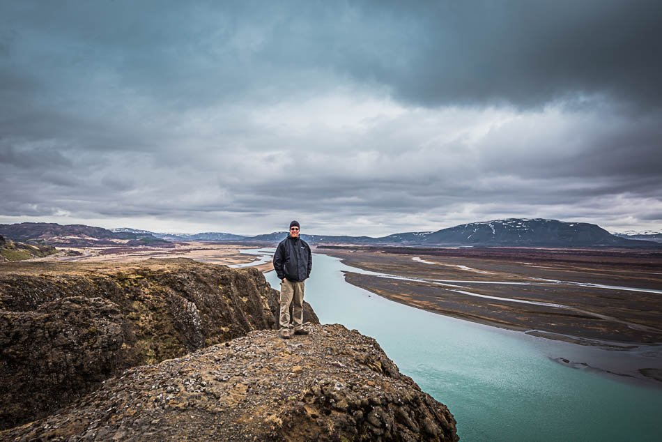
So contemplating nearly two cubic miles of lava is an equal stretch. The lava flows and ash-falls covered hundreds of square miles, rolling out from the volcano’s craters like molasses. The volcano itself is a long, low ridge with multiple craters — the view from the rocky headland at Gaukshöfði takes in the wide, aquamarine river Þjarsá as it carries glacial meltwater, with the low mound of Hekla looming across the river. We climbed up the steep path to get the really good views along the river and watched the storm clouds as they rolled in through the valley. Sometimes, just sitting on a rock and watching weather can be worth the climb.
It was also worth the climb to see two other tourists scampering over the paths with a giant selfie-stick and a go-pro camera. They were determined to take one of those perspective-bending shots where you think the person is dangling in midair, or something, and kept running out to the edge of a stone outcropping and leaning precariously out. I think my blood pressure went up a few points just watching them.
Another of Iceland’s “-est” waterfalls is just up the river, and we skittered down the rocky path and back into the car. Since we were at Urriðafoss this morning, we’d been playing car tag with another camper van and a family in a teeny little Ford — we’d pull in to see the campervan (painted with Z-ball anime characters) leaving the parking lot, and as we packed up to leave, the Ford would disgorge five or six people to walk slowly up the path we had just come from. Sometimes we overlapped a few minutes, other times we all arrived at the same time. It seemed to cause some consternation with the family in the Ford, and they started to lag further and further behind.
We must have stayed long enough at Gaukshöfði for them to catch up, and their little blue car pulled into the parking lot just as we pulled out. We waved jauntily at them and watched as they started the climb up the hill.
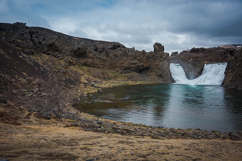
Hjalparfoss is notable more for the fantastical basalt columns surrouding it than the actual waterfall. It’s a small drop, split into two actual flows of water, into a small roundish lagoon that then dribbles off down to meet the river. We’ve seen larger and taller and wider falls, of course, but this is a rather unique location with twisted stone fanning out around the falls. The columnar basalt forms when lava cools slowly, allowing it to break into regular shapes. Here, they were twisted and spread out around the basin like spaghetti.
The shallow field leading down to the lagoon is a lovely place for a picnic. It’s easily accessible from the road, too, which is nice. I’ve been getting used to tromping all over creation to see things (usually uphill, isn’t that always the way it is?) and being able to get out of the car and see a waterfall is rather nice.
Of course, we got turned around and started the drive to Stöng and so totally missed the four-star Þjofafoss, only a few kilometers away (although on the other side of the headlands). I have added it to the list for our next trip, it is marked as “do not miss’, and, typically, we missed it. I got so caught up in figuring out what gravel track to take to the Viking farmstead of Stöng that I totally overlooked it. Hmph.
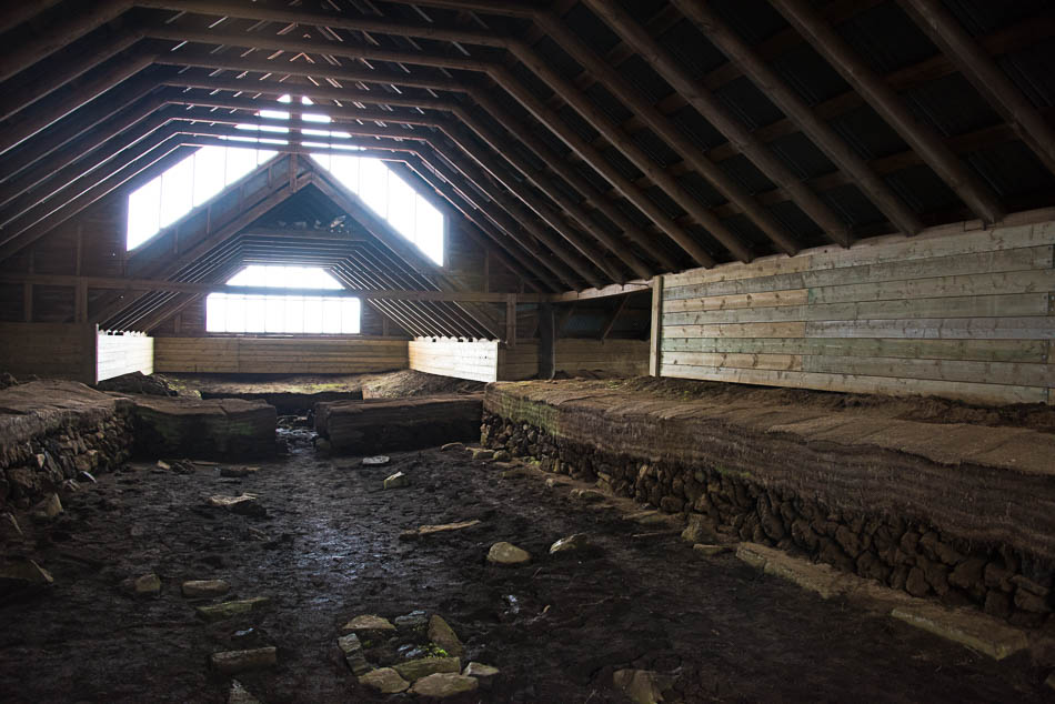
A rough gravel road — definitely drive-able in a non-4×4, but it would be a teeth-rattling ride — leads northeast from Route 32, along the stone cliffs and eventually leads to Stöng and the very picturesque Gjain canyon. While there is a reconstructed museum version of the farmstead back on Route 32 (Þjóðveldisbærinn Stöng), the original excavations are a short walk from the road after you jitter along a washboard gravel road, trying not to let your teeth clack together and hoping nothing falls off the car. The path is a bit overgrown, but easy. Beneath a modern tin roof and wooden barn are the remains of foundation walls for a great hall, living quarters, storage, even bedrooms. There is a small plaque just inside the door outlining the excavations (begun in 1939), and explaining a bit about the structure, but mostly it’s just the low turf walls and mud floors and a bit of imagination to make this into a settlement-era farmhouse, one of dozens excavated in this area, that was buried under the ashfall from the eruption of Hekla in 1104. There isn’t much to suggest how it was to live in this building — you’d need to visit the reconstructed museum, which is only open summers. I’m thinking lower, darker, smellier, and far smokier, and probably involving a bunch of livestock.
In all of my lists, one of the “must see” waterfalls in Iceland is a little-known cascade, Brúarfoss, the “blue waterfall”. A horseshoe-shaped cascade of brilliantly hued water. But it’s hard to find, not off a main road, and accessed either by foot walking up-river, or through a summer housing development. I found the following directions online: “Take the third left into the summer house area. Stay left on the gravel road until you find a small parking area. Walk towards your left until you see a small bridge. Cross the bridge. Walk towards your left…” The photos are stunning, and I wanted to see it in person.
We failed.
I mean, we tried the directions. We found the housing development, took the only un-gated entrance (the third, as noted). The area is a winding series of connected gravel roads, a plethora of ‘private road’ signs, and no obvious way to get to the end of the development. The obvious path in Google Maps does not match the actual roads and we weren’t able to get to the end, even after two tries. There is supposed to be a small, two-car parking area there. We kept ending up close to the road we wanted, but with no obvious way to get there. GIven that two of the three entrances are closed and locked with gates, for residents only, we didn’t push too far past the fences and into what looked like people’s front yards. I’m sure that it’s still possible, but we surrendered. It looks like there has been a lot of road construction (paving) in the area, so I think the original directions may not work any longer — at least not by car. We seemed to be able to parallel the road we wanted, but not get to it at any point. Perhaps the locals got tired of cars passing through? Or we just are too polite to head off onto what appears to be people’s driveways.
I found additional directions that suggest parking by the side of the road on Route 37 where the river crosses (just west of the intersection between Rte 37 and Road 355). Then cross the fence via a stile and hike upstream to the waterfall. It looks to be a 35-45 minute walk along the water. We’ll have to try that next time.
I hate it when we simply cannot find something that we want to see. It’s happened before, usually when trying to find some pile of rocks that was at on time a castle, or looking for a specific stone or marker in some farmer’s field. I always get frustrated out of proportion to the missed item. There are, literally, a thousand gorgeous views and hundreds of waterfalls in Iceland, missing just one isn’t going to ruin anything. But nonetheless, I pout. Mark finds it funny, which is better than being annoyed, I guess.
I was putting my faith in the weather forecast again, which said that the sun should be shining in Þingvellir around 6pm, and so we wended our way back out to the road and headed to the park. The clouds didn’t look particularly cooperative, but Iceland is definitely a “if you don’t like the weather, wait ten minutes” sort of place, so I was hopeful.
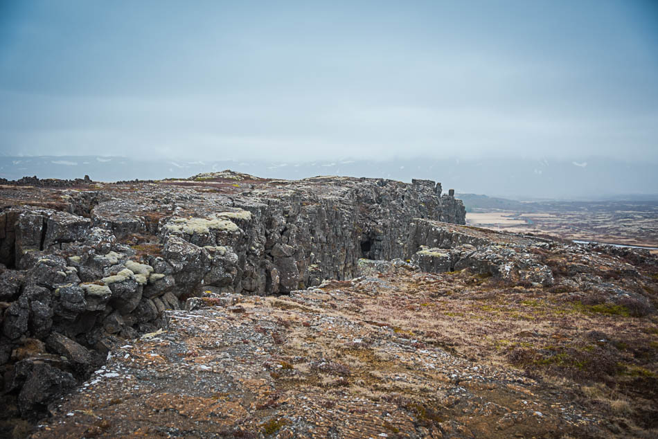
I mostly appreciate Þingvellir National Park for the rift-valley and interesting geological features — Silfra rift, the Almannagjá fault, the lake. It’s a gorgeous area, with the added enticement of being able to walk between the North American tectonic plate and the Eurasian plate. The gap is getting larger by about 2cm a year, so the area is very seismically active. It’s pretty cool to be able to touch the walls of the canyon and know that you are stepping from one region to the other. Mark went scuba diving in the Silfra rift yesterday, and was able to touch both plates at the same time.
But Þingvellir is known for much more than just geographical wonder. It holds an important place in Icelandic history, being the site of the original Alþingi, the parliament. There are a number of historic sites in the park — the Law Rock, churches, the gathering area for the assembly. This has been the center of politics for centuries. It was the primary site during the commonwealth area, and the first Alþingi is considered the founding of Iceland in 930. It remained in power until Denmark took over Icelandic rulership in 1662.
Which is all an interesting background to add some color to the large fields and scant remains that follow the path through the park. Fields, rock formations, pools — there really aren’t any confirmed sites here, even the famed “Law Rock” is just a guess. It’s more the idea of it, the importance this region had in the the history of Iceland, that appeals.
But no sun, alas. The weather forecast was once again a bit off. Clouds and even a bit of fog, but none of the promised sunshine arrived.
Well, not until later when we got back to Selfoss. We’re back at Guesthouse Garun Skolavellir. Last night was so comfortable, we decided to stay again. We walked to dinner and had excellent burgers at Kaffi Krus. The restaurant is in an old house, with the kitchen in the basement, the bar and a few tables on the main floor, and a big dining area upstairs. The servers took the orders, walked down two flights of narrow stairs to the basement kitchen, back up two or four flights with the plates. Then they washed the plates on the main floor and carried the cleaned dishes downstairs again to start the process all over. Having a job there would be like living on a stair-stepping machine. Or hiking up and down from the lowest bowels of hell hundreds of times every day. Wow.