Snafellsness Peninsula Skoggafoss, Eldborg, Gerduborg, SOuth shore, Arnarstapi, Snaefellsnesjokeull, Hellnar coast, Caves, Saxholl, Kirkjufellsfoss, Kirkjufell, Beserkerhruan, Bharnarhofn
The western peninsula is often called “Iceland in Miniature” — glaciers, waterfalls, lava flows, rivers, farms, volcanoes, you name it, it’s here on Snaefellsnes. I was particularly looking forward to it, as it’s the location for my favorite movie, Walter Mitty. Plus, today dawned sunny and gorgeous and we were ready to see things!
The bathroom in our guesthouse was, I mentioned, enormous. Bigger than any of the bedrooms, and tiled in orange and green. The shower was impressively hot — and stinky of sulphur — and left me smelling faintly of floral shampoo and eggs. You just get used to it, I guess. Mark made coffee upstairs and we were off right to find breakfast — every town has a bakery and can be relied on for hot coffee, breakfast pastries, and ham-and-cheese croissants. Easy!
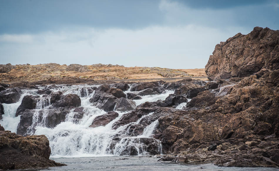
Only a few kilometers from town, the road snakes through a number of rather stark-looking farms, and our map has a small waterfall, Skoggafoss, marked on it that looked close enough to the road to stop and see. Well, it would have been quick if we’d picked the right loop of road to drive down, but we missed the first time and ended up in someone’s farmyard. Backtracking, we got back to the main road and tried the next one — success! The gravel road looped around to a small parking area where we discovered another couple cooking breakfast beside their little Happy Camper. I think they had parked there overnight to camp. It was windy and cold, they looked pretty miserable trying to make eggs and oatmeal, to be honest. We licked the frosting from our pastries off our fingers and pulled on hats and gloves to walk around to see the falls.
Mark hiked all the way around the little lagoon for pictures, and I could see him trying ot figure out just how to climb up the rocks to cross back over that way. The water isn’t deep but it’s moving pretty fast and the rocks are slippery. Trying to hop across the waterfall that way would have been an exciting (and probably wet) accident. He opted for returning the long way round. There is a way to climb up the rocks and walk along behind the falls to cross at a narrow, shallow part of the creek, and then walk back along the road, though. By the time we got back, the two women in their camper had moved on.
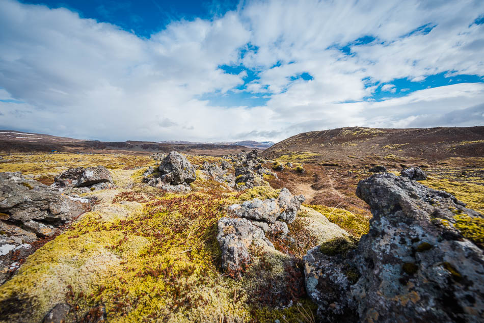
As we drove up across the first peninsula, we could see the long, low mound of Eldborg crater in the distance, right in the first cove along Snaefellsnes. It’s hard to miss, really, and it is the start of a lovely drive along the southern coast. We decided to stop first at Gerðuberg, the iconic basalt-column cliff. The landscape went from rolling green grass to moss-covered rocks as we neared the peninsula and the kilometer-long escarpment.
 Gerðuborg is a spectacular cliff — instantly recognizable as the same rock formations that make up The Giant’s Causeway in Ireland, or the rock surrounding Fingal’s Cave in Scotland. This sort of hexagonal stone pillar shows up all over the world, of course. Any time lava cools quickly, it fractures into these regular shapes. The cooling lava contracts along regular fault lines, and depending on how fast it cools, the columns can be many feet across or only a few inches.
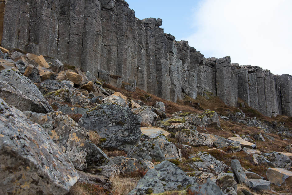
We walked along the base of the cliff for a ways, marveling at the enormous stones littering the slope, some of them the size of dining tables. Looking at the wall of stone, I got the disorienting sense that it was moving, like marching soldiers advancing across the field, the front row falling to the ground before the inexorable push of those behind.
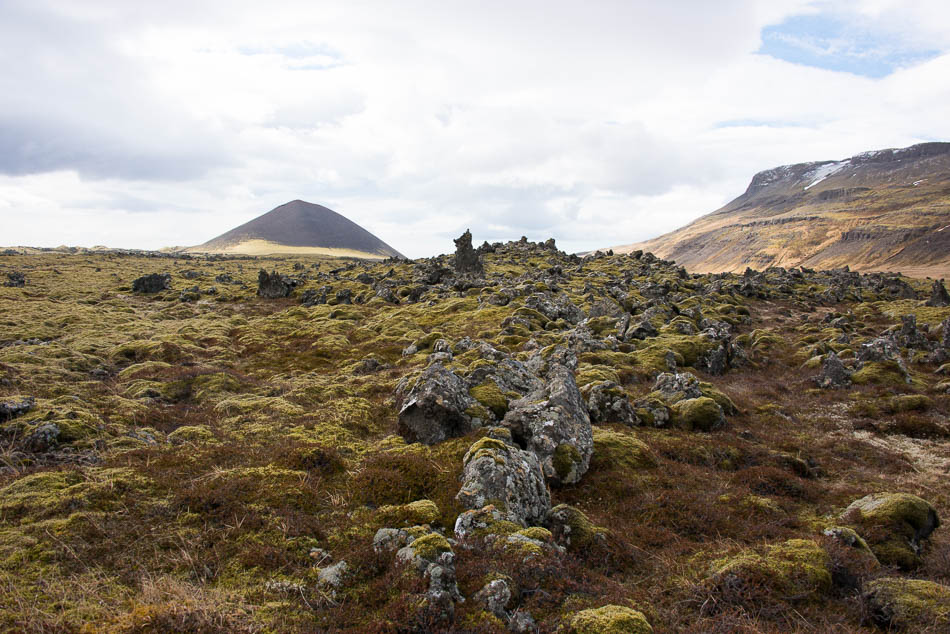
There are two large volcanic craters and a lava field in this area, so we drove past the ciffs and snaked around the red volcano, which is labeled Raudamelsölkelda (although I can’t find anything in google – perhaps it’s really Raudhamelur? That may be the region name). We drove along the gravel road, skirting the red-stone volcanic crater and out into the lava field.
Which is where we discovered ‘window weather’. It looks fabulous outside — blue skies, sunshine, glowing green moss on the lava. But when you step outside, the wind is howling so fiercely it is hard to stand upright. It will knock you off your feet if you aren’t careful, but there are no plants or grasses or shrubs to give you any indication that the wind is blowing at all. No frame of reference — so it looks gorgeous out the window.
(And hold on to your car door when you open it, and the hatchback, too, if you have one. The wind can wrench those things around in a second and they door won’t close again.)
I had a hard time keeping the camera still, even on a tripod. Admire the glorious blue sky and fuzzy moss and realize that the winds were probably topping 6o mph. The lava fields go on for miles, and it is only a teaser for the rest of the peninsula — lava flows and dozens of volcanic craters are to come.
Route 54 goes around the peninsula, and the coastal drive is beautiful and stark and inspiring. The wind hasn’t abated in the least, it buffets the car even though the ‘window weather’ continues to look perfect. Mark decided he was starving, so we stopped at the first (and only) restaurant on the horizon, Vegamót Snaefellsnesi — a combo cafe, bust stop, gift shop, and gas station. Once again, I’m reminded that Iceland exceeds expectations every time with roadside diners. The food is good, the restaurant is cute, and everyone is nice. I had a very tasty Caprese sandwich and Mark had soup and bread. There were three other couples in the little cafe, on Icelandic, one English, and one German (or Austrian, I can’t tell). The waiter slipped effortlessly between Icelandic, English and German.
I am always astounded at people who can fluently speak two or three or more languages, I can speak a little Russian, a little more German, a little Italian, a bit of Irish Gaelic, and have pidgen-level interactions in Spanish. I even learned a teensy bit of Icelandic. Sort of. Tourist level language skills — hello, how are you, where is the X, reserve a table or hotel, get directions. Enough to get by if I had to. I was immensely proud of my ability to make restaurant reservations on the phone in Italian. But waiters and clerks everywhere switch between languages like flipping pages. German, Italian, Russian, Chinese, Spanish, all in one evening. A restaurant manager once responded to my admiration with, “oh, but it’s only restaurant langauge!” after having a conversations in at least three different languages in the previous few minutes.
Perhaps the most astounding facility with language was in Egypt, though, where young kids hawking maps and postcards accosted everyone with “Buy postcards? Do you need a tour? Restaurant?” in at least a dozen languages. They’d pause for a moment, listen for whatever language the tourist was speaking, and launch into their spiel. I’m sure they had a total of twenty words, but the presence of mind and ability to respond in any of them was impressive.
Gas in the car, tasty dessert in our bellies, and we’re off to see seals. Or not see seals, as the case may be, at Ytri-Tunga. The wind was howling, and we may have seen a seal or two offshore, but we’re too early for the beach to be populated by hundreds of harbor seals and seabirds. The beach is on private property, but has a nice parking area and you can walk down along the water and enjoy the view of the beach. There are a number of beaches in Iceland that have resident seal-colonies, breeding season starts in June and through the summer.
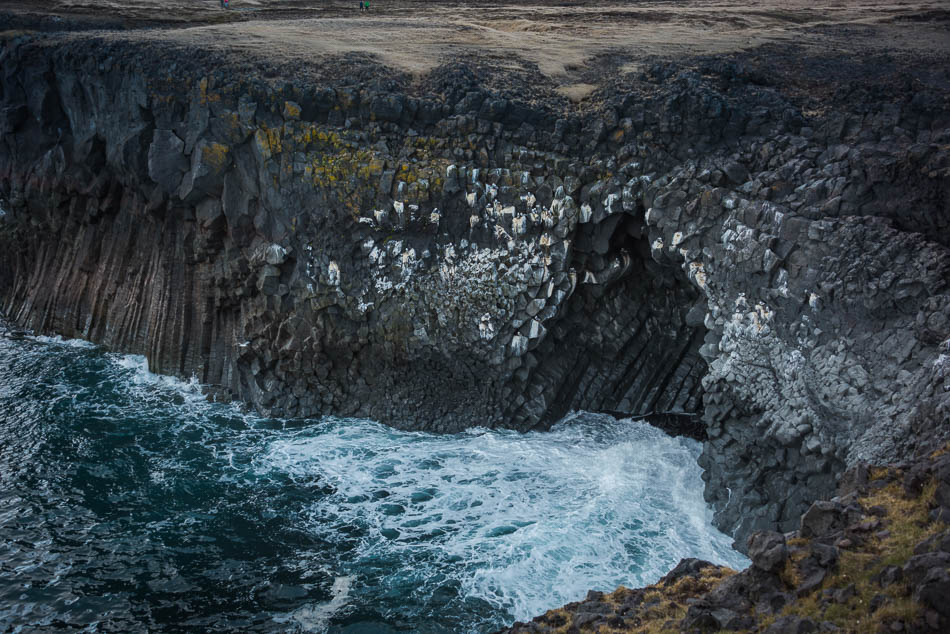
The south western coast of the peninsula is dotted with fishing villages and beaches, with sea bird colonies and interesting rock formations. Inland is a tall pyramid-shaped mountain, Stapafell, one of many that string out along the peninsula,. and the road snakes along the coastline to Anarstapi. The town is tiny, but the path to the sea cliffs reveals stacks and sea caves and arches — Gatkletter and Hellnar are the primary ones, but interesting shoreline and basalt column cliffs run along the coast for a few kilometers here.
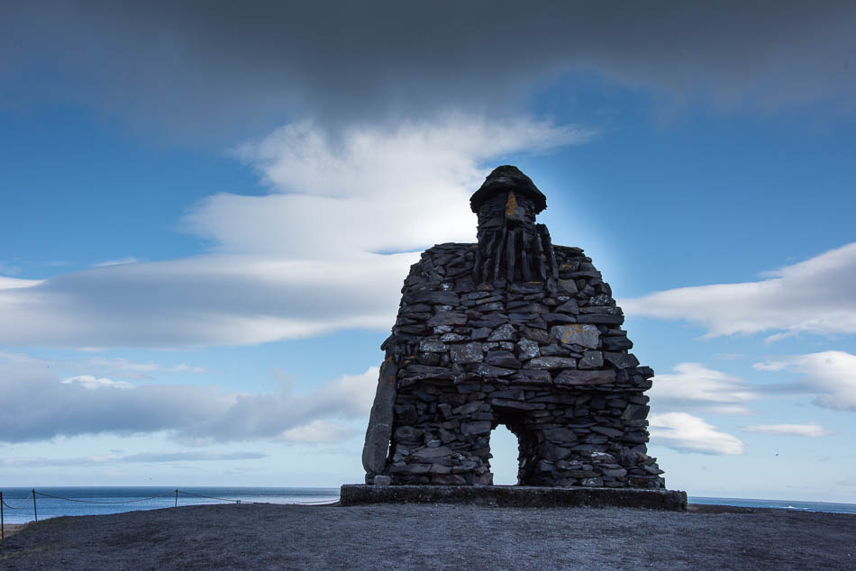
My favorite, though, is the giant viking-troll statue that stands at the cilff; the figure is Bardur Snaefellsas, who is mentioned in the Bárðar sagas. He is the protector of the region and supposedly lives in the nearby magic mountain of Stapafell.
Just up the road is a lovely viewpoint, which has a plaque that had us laughing, albeit in a macabre way: a info board telling the story of Axlar-Björn, the notorious axe-murderer of Iceland. Who lived here on the peninsula in the 16th century. Yup, the most notorious serial killer in Iceland and they had to go back four centuries. There are a number of folk-tale stories about his life, but he would take travelers into his home as guests, then murder them, 18 in all. Here we are looking over a gorgeous vista, basking in the sunshine, reading a rather gruesome story about a serial killer.
There are series of arches along the Hellnar Coast, and we hiked out from a radio-station through a weird lava field to get a better view of a large rock formation, which managed to be brilliantly lit by a ray of sunshine just as we arrived. There is a walking path all along the cliff top here, you can walk fro town to town if you want to — but public transport is sparse and you may end up walking back as well.
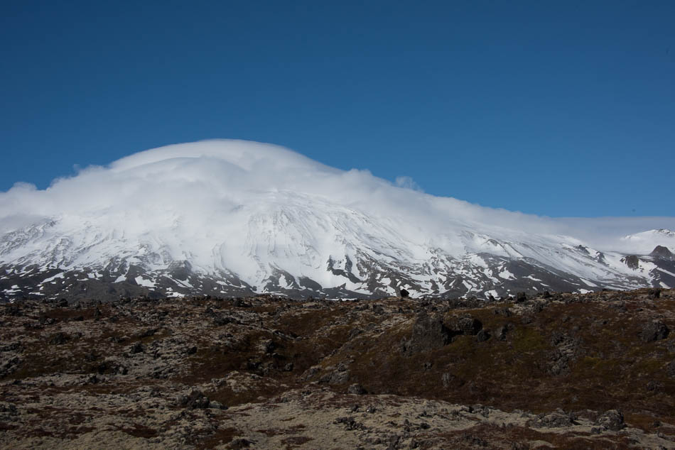
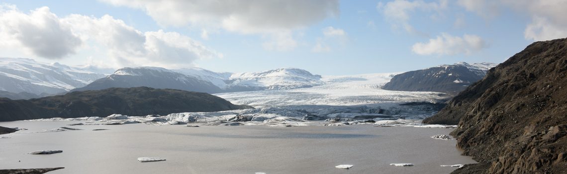
As we rounded the end of the peninsula, we drove around one of the smaller glaciers, Snaefellsjokull. It lies over a volcano, as do nearly all of them in Iceland, and it seemed as if it was creating it’s own weather — clouds kept sliding down the sides of the mountain and hovering over the top. It looked for all the world like it was steaming gently. (Which is a nerve-wracking thought, when you consider that there is an actual volcano and lava chamber beneath the ice cap.) This is the first real glacial ice-cap we’ve seen, and it’s a tiny one compared to the giant Vatnajokull glacier in the southeast. Frankly, it looks very much like the Rocky Mountains here in Colorado — just snow-covered, not actually glaciated. I’m excited to see the larger glaciers as we continue around the island. Snaefllsjokull, I should mention, is a stratovolcano and is the entrance to the center of the earth, in Jules Vernes’ book.
We’ve seen almost no cars since we stopped for lunch and gas, a few people at Anarstapi and then they seemed to either turn back, or at least fell far enough behind that we started to feel that we were the only ones around. Mark skidded to a stop by the side of the road as we turned north, though, commenting on ‘wierd caves’. I hadn’t seen anything, but he’d spied these weird spaces by the side of the road that looked like drains — and turned out to be lava caves (or at least, lava bubbles) under the lava flow that had partially opened to the road. They were shallow, but seemed to stretch back under the lava field for quite a distance.
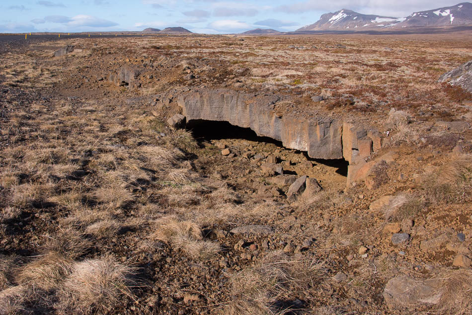
As you can see — the rest of the landscape is pretty sparse and flat. I did talk him out of trying to poke deeper into the caves. He always wants to climb down or in or over things; he’s always been a little laissez-faire about personal safety on vacation. He walks out on cliffs, leans over things, it scares me to death!
Just up the road are the cluster of volcanic craters of the Saxholl field. These are cinder craters, and you can park nearby and climb to the rim for some pretty views over the lava flows. They are extinct, of course; no steaming lava running underfoot as far as we can tell. The whole area is part of the Snaefellsjokull National Park, which encompasses the glacier and lava fields on the very western tip.
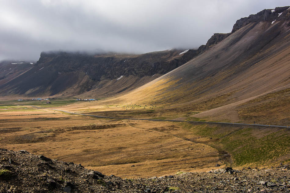
Along the northern coast, the landscape changes quite a bit, from tall sea cliffs and beaches to a series of rocky fingers poking out into the Breiðafjörður. The road follows the coastline for awhile, then there are bridges and causeways crossing along the mainland, with only narrow gravel roads or no roads at all to the points. Some of the most photogenic areas of Iceland are stretched along the north coast with a series of small towns, Rif, Olafsvik, Grundarfjorður. We arrived as the afternoon sun was getting lower in the sky – not quite the ‘golden hour’, but it highlights the rocky landscape beautifully.
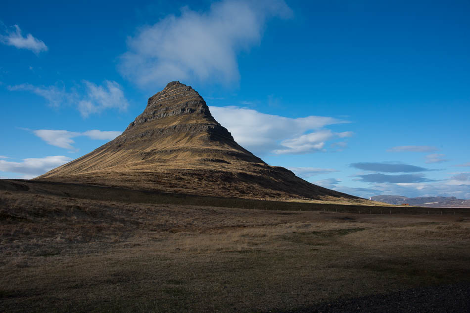
Unfortunately, taking pictures directly into the sun meant we had lousy photos of Kirjufellsfoss, a lovely little waterfall accessible from the side of road, nestled in a long oval riverbed strewn with mossy rocks. Directly across from the waterfall, across the road, is Kirkjufell, ‘church mountain” — perhaps the most photographed mountiain in Iceland. Check google images and you’ll see some amazing photos of the mountain with the northern lights dancing above them. We aren’t going to see that, of course, May is spring and longer days and very little darkness, but we are just starting to see the green emerge and perhaps even a few flowers poking up. This place must be amazing in mid-summer.
There is a hiking trail around the mountain, and some lovely views from the peak, and there are some lovely beaches. It’s still a bit windy for enjoying them, at least for us. I can’t find any confirmation, but it certainly looks like a volcanic basalt plateau. The top is flat (although you can’t see from my photo), and the mountain is made up of layers of lava and tuff interspersed with sedimentary layers and fossils (from between eruptions of the nearby volcanoes). Rather like a 10-12 layer cake. The rocks and mountains here display the whole geological history of Iceland — starting with volcanic eruptions about 18 million years ago through glaciation and erosion. This is an old part of Iceland, and it shows.
Many people drive around Snaefellsnes peninsula as a day trip from Reykjavik. It would be a long trip, but doable. More drive around or through the peninsula on Route 54 to reach Stykkisholmur, a medium-sized town on the north shore that is the ferry station to reach Flatey Island and further on, the Western Fjords. It would save a long drive along the southern coast of the fjords, but we are planning on taking the long way and enjoying the windy roads along the southern shore.
Flatey is a small island in Breiðarfjörður, the large bay between Snaefellsnes and the western fjords. It is the largest island in the Western Islands (about 40 islands). The island is inhabited, a handful of people are year-round residents. The old town is a lovely collection of restored houses. a hotel, and a few restaurants and the island has become a tourist destination during the summer. We did not take the ferry out to the island, it is still too early to have revved up tourist services for the summer. The hotel opens much later in May. You can take the ferry out to the island and walk around and return the same day. Note that cars are not allowed on the island — but since it’s barely 1km x 2km, it’s easy to walk around.
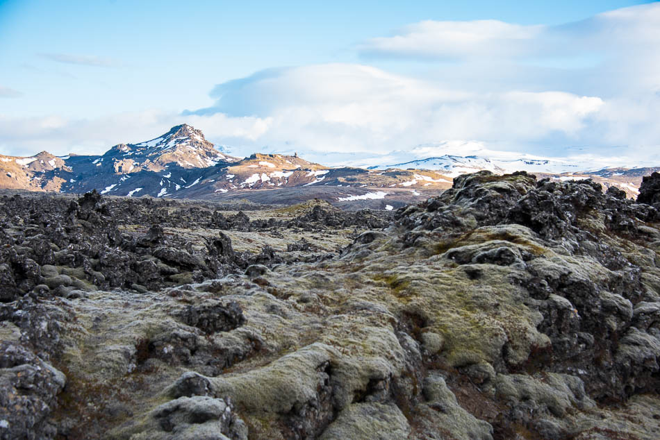
We did, though, drive through the Berserkerhraun, stopping to take pictures of the fantastical lava formations that stretch on both sides of the road. We’ve seen a dozen lava fields so far — even in just four days — but this one is spiky and wild, like a foaming sea whipped up by a storm and frozen in place. Piles of loose rock held together with a layer of soft moss. There is a road through the lava field — the legend is that it was cleared by two beserkers at the command of a local farmer. One of them wanted to marry the farmer’s daughter, and as a test, the farmer set what should have been an impossible task: clear a path through the lava field. If the suitor could finish the task, he could marry the girl. So motivated, he and his friend blasted through the lava field and returned triumphantly to claim their reward…and the farmer promptly killed them both. A lot of legends are like this, everyone dies in the end, sometimes gruesomely.
We drove around the field to a lookout point and made sandwiches, while deciding how far we would go before camping for the night. We decided to get as far into the western fjords and drove along the south shore of Hvammsfjórður and up the coast. The main road slices across the peninsula and over a mountain pass before arriving in Bjarkalundur just as the sun was setting.
We’re staying at the Hotel Bjarkalundur for the night, they have a hotel, cottages, and camping available — the generous host let us park in their camping area for free, since they were not “officially” open for camping, but the main office and toilets were open, so we were fine. The hotel is not busy, I’m sure we could have gotten a room inside if we wanted on, but I’m still on the “but we’re camping, dammit!” streak, and insisting that we at least try to spend most of the nights in the camper as planned. Missing a shower isn’t going to kill us. The only people we’re possibly going to offend are ourselves, of course.
There were two guys from Canada in a Happy Camper already parked and asleep by the time we arrived, so we aren’t the only ones driving around this early! We parked behind a berm to try to stay out of the wind, and even so, the car rocked with the gusts for most of the night. It’s pretty cold up here, but the sleeping bag is very poofy and warm, and Mark is a blast furnace, so I feel right to sleep and didn’t wake up until morning.
I love your story! You are required to finish it someday. 🙂